

Geophysicist | Geodesist | Seismologist | Open-source Developer
I am currently a post-doctoral researcher at the Department of Earth and Planetary Science, UC Berkeley, United States. Although I am intrigued by all sorts of data analysis projects, my primary research interests are in Geophysics, and Geodesy. I work on the tools that support data-intensive research and build software tools for researchers.
Computing and Technical Skills
| Computing | Technical |
|---|---|
| Web Development [backend (preferred), frontend] | Computer Operating Systems: MacOS (Mojave), Linux distributions (Ubuntu, Fedora, Opensuse), Windows (7) |
| Open-source programming (scientific computing, data visualization, and achieving automation) |
Database Development/Management: SQLite, PostgreSQL and Pandas DataFrame, AWS-S3 |
| Python (primary), Bash/csh, R, C, Perl, Fortran (and Gnuplot, MATLAB, LATEX, HTML/CSS, Markdown, Javascript (JQuery) |
Designing: Proficient in Adobe Illustrator, Adobe Photoshop, iMovie, HTML/CSS and JS |
| Generic Mapping Tools, Basemap (Python), Bokeh (Python) for plotting high resolution maps |
Writing (offline): Microsoft Office Suite (Word, Excel, Powerpoint), Mac Pages and Keynote (for manuscript), LATEX (for extensive documents), Jupyter Notebook (for presentation of software packages) |
| Seismic Analysis Code (SAC) and Obspy (Python) for analyzing and visualzing seismic waveforms | Writing (online): Wordpress, Medium (for blogging), Markdown, Jekyll, Sphinx documentation |
Skills & Proficiency (Relative to my proficiency target)
Python
MATLAB
Fortran
C/C++
Bash
Perl
HTML5 & CSS
Javascript
Open-source Projects
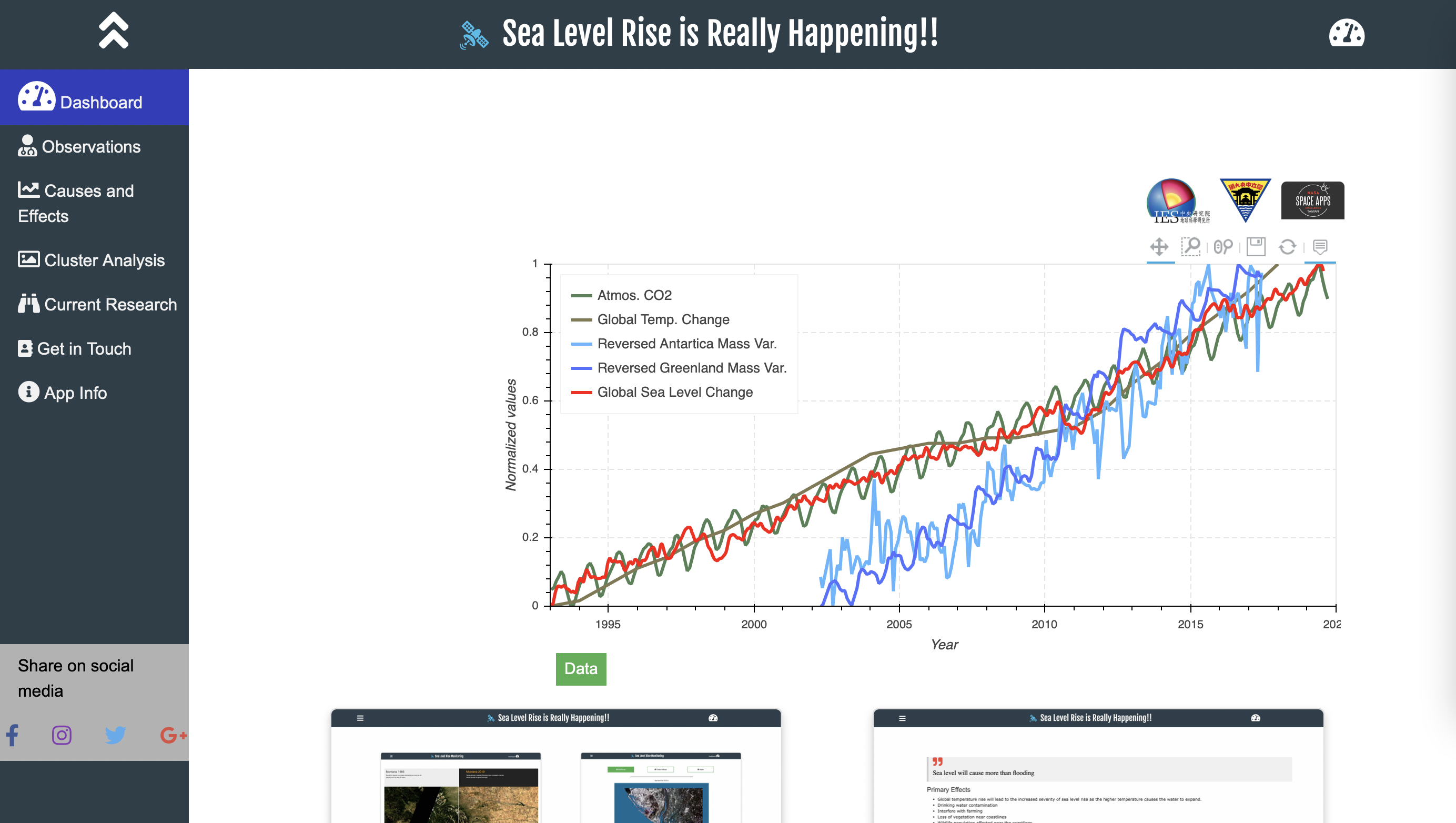
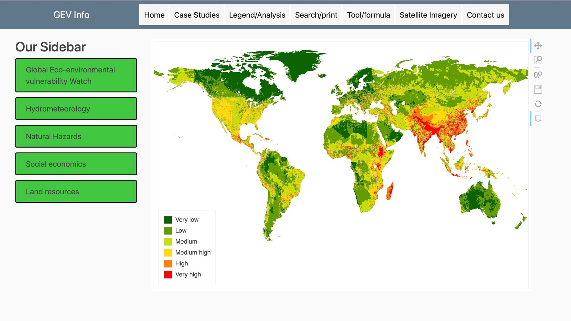
Sea-Level Rise Monitoring
Web-Application that aims to integrate NASA data (satellite images and tabular data) to create sea-level rise monitoring picture for general awareness.
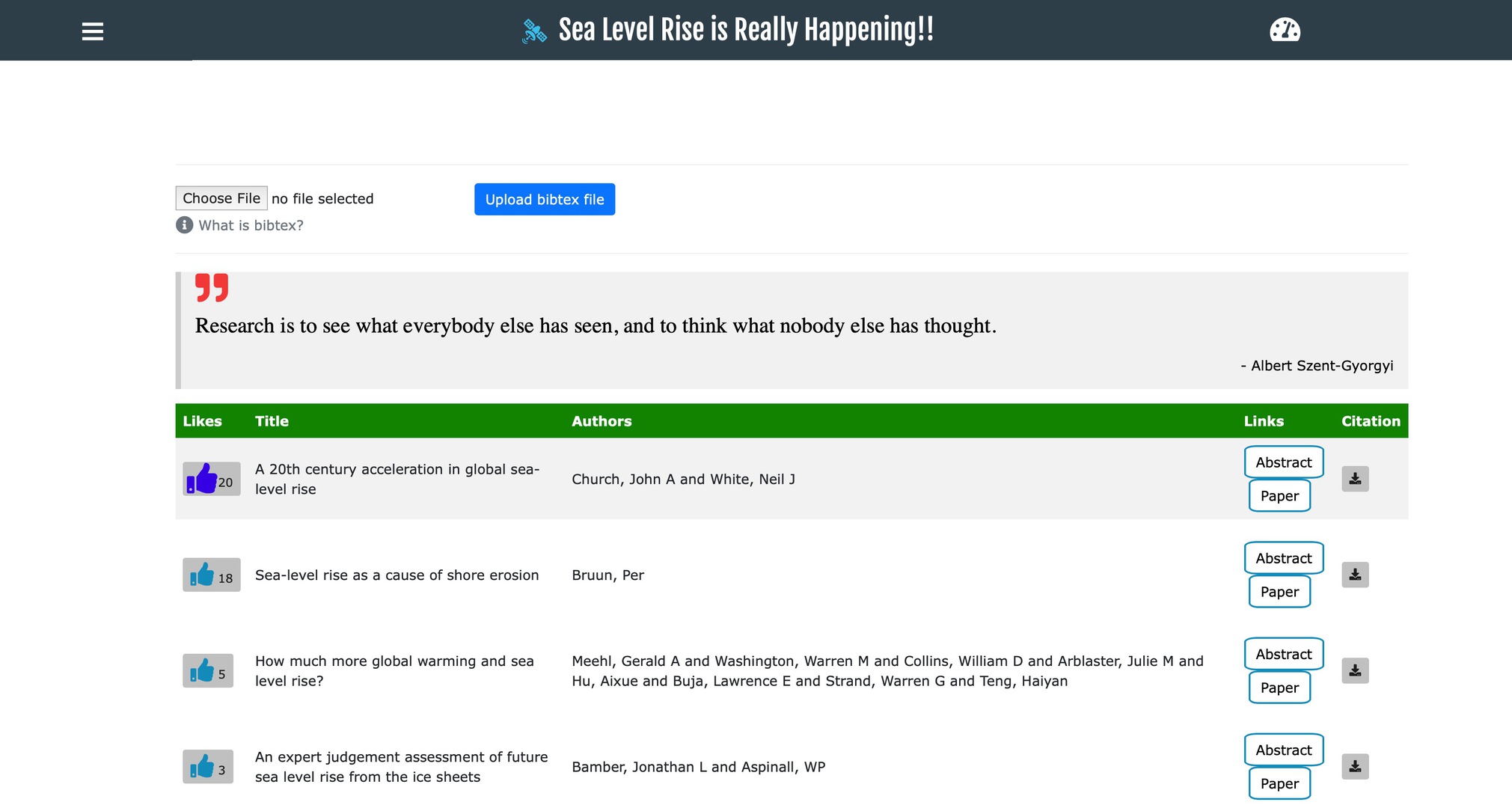
Bibligraphy Database
Automatically obtain publication details using Google Scholar API and stores at AWS S3.

FerryMan
A web application to identify the "comfort" zone of different species based on their Ecological Index.
- dtwhaclustering: A python package to cluster geodetic time series
- Voice-Plotter: A GUI application to visualize real-time ambient sounds
- Miniseed2mat: Convert miniseed data format to MATLAB's native MAT format
Current Research
- To finalize codes and data collection and develop a 3D elastic model of deep structure beneath the Yellowstone hotspot using an approach called "box tomography"
- Dynamic Time Warping as an Alternative to Windowed Cross-Correlation in Seismological Applications
- On Analyzing GPS Displacement Field Variability of Taiwan: Hierarchical Agglomerative Clustering based on Dynamic Time Warping Technique
- Fully-automated Focal Mechanism Determination System and it’s Application on the Events Located in Northern Philippines
- Spatial Analysis of Anomalously Large Co-seismic Deformation in the 2016 ML6.6 Meinong, Taiwan, Earthquake using EOF method on dense continuous GPS data of Taiwan
- Automated receiver functions and shear-wave splitting measurements beneath seismic stations in the USArray and Germany by STADIUM-Py
Ph.D. Thesis
- Ph.D. Dissertation: Click here to READ
Publications
- Kumar, U., Legendre, C.P. (2022) Crust-mantle decoupling beneath Afar revealed by Rayleigh-wave tomography Sci Rep 12, 17036 https://doi.org/10.1038/s41598-022-20890-5READ
- Kumar, U., Cédric. P. Legendre, Jian-Cheng Lee, Li Zhao, Benjamin Fong Chao (2022) On analyzing GNSS displacement field variability of Taiwan: Hierarchical Agglomerative Clustering based on Dynamic Time Warping technique Computers & Geosciences, 105243. https://doi.org/10.1016/j.cageo.2022.105243READ
- Kumar, U., C. P. Legendre, L. Zhao, B. F. Chao, 2022. Dynamic Time Warping as an Alternative to Windowed Cross Correlation in Seismological Applications, Seismol. Res. Lett., doi: 10.1785/0220210288.READ
- Cedric P. Legendre, Utpal Kumar, Benoit Deffontaines, Bor-Shouh Huang, 2022. Seismic anisotropy beneath Sunda Block: a Synopsis, Under review
- Kumar, Utpal, & Legendre, Cédric P. (2021). STADIUM-Py: Python Command-line Interface for automated Receiver Functions and Shear-Wave Splitting Measurements (1.0). Zenodo. https://doi.org/10.5281/zenodo.4686103
- Kumar, U., Legendre, C.P., Huang, B.S., 2021. Crustal structure and upper mantle anisotropy of the Afar triple junction. Earth, Planets Sp. 73, 166. https://doi.org/10.1186/s40623-021-01495-0 READ
- Seela, B.K., Janapati, J., Kalath Unnikrishnan, C., Lin, P.-L., Le Loh, J., Chang, W.-Y., Kumar, U., Reddy, K.K., Lee, D.-I., Venkatrami Reddy, M., 2021. Raindrop Size Distributions of North Indian Ocean Tropical Cyclones Observed at the Coastal and Inland Stations in South India. Remote Sens. . https://doi.org/10.3390/rs13163178 READ
- Kumar, U., Chao, B. F., & Chang, E. T. Y. (2020). What causes the common‐mode error in array GPS displacement fields: Case study for Taiwan in relation to atmospheric mass loading. Earth and Space Science, 7, e2020EA001159. https://doi.org/10.1029/2020EA001159 READ
- Kumar, U., and Chao, B. F., (2019), Crustal Motion of Active Plate Convergence in Eastern Taiwan, 2007-2018: Agglomerative Clustering based on Dynamic Time Warping, Earth and Space Science Open Archive, 1, doi: 10.1002/essoar.10501536.1.READ
- Janapati, J., Seela B. K., Lin, P.-L., Wang, P. K., & Kumar, U., (2019), An assessment of tropical cyclones rainfall erosivity for Taiwan, Sci Rep 9, 15862 https://doi.org/10.1038/s41598-019-52028-5 READ
- Kumar, U. Chao, B.F., Hsieh, Y., Chang, E.T.Y., 2017. A meteor shockwave event recorded at seismic and infrasound stations in northern Taiwan. Geosci. Lett. 4. https://doi.org/10.1186/s40562-017-0079-2 READ
- Seela, B. K., Reddy, K. K., Janapati, J., Rao, T. N., Lin, P.-L., Liu, C.-Y., & Kumar, U., (2016), Precipitation and cloud microstructure variations between two Southern Indian stations, Proc. of SPIE Vol. 9876, 98761O. http://dx.doi.org/10.1117/12.2218458 READ